syvainjule / locator
基于开源服务/Mapbox的地图和地理定位字段
Requires
README
一个简单的基于开源服务和Mapbox构建的地图和地理定位字段。
概述
此插件完全免费,并采用MIT许可证发布。但是,如果您在商业项目中使用它并希望帮助我维护,请考虑随意捐赠。
1. 安装
Kirby 3: 1.1.4及以下. Kirby 4: 2.0.0+
下载并将此存储库复制到/site/plugins/locator
或者,您可以使用composer安装它:composer require sylvainjule/locator
2. 设置
默认情况下,该字段设置为同时使用开源服务进行地理编码(Nominatim)和栅格渲染(Positron),无需任何API密钥要求。
请注意,这些服务受严格的使用政策约束,请始终检查您的使用是否兼容。否则,请设置字段使用Mapbox,详细信息见下文。
您也可以直接输入纬度/经度坐标,绕过地理定位(格式如下:15.23456, -30.67890)。
mymap:
  label: Location
  type: locator
3. 栅格服务器
3.1. 开源/免费栅格

您可以选择其中之一包含的4个免费栅格服务器
wikimedia(使用条款)openstreetmap(使用条款)positron(默认,使用条款 [在免费底图服务条款下])voyager(使用条款 [在免费底图服务条款下])
mymap:
  type: locator
  tiles: positron
您也可以在安装的主config.php中全局设置此选项,这样您就不必在每个蓝图中进行配置
return array(
    'sylvainjule.locator.tiles' => 'positron',
);
3.2. Mapbox栅格
mapbox.outdoors→mapbox/outdoors-v11(默认mapbox主题)mapbox.streets→mapbox/streets-v11mapbox.light→mapbox/light-v10mapbox.dark→mapbox/dark-v10
如果您的使用不符合上述政策(或者您不想依赖这些服务),您可以设置字段使用Mapbox的栅格。
您必须在安装的主config.php中设置您想使用的栅格的id以及您的mapbox public key。
return array(
    'sylvainjule.locator.mapbox.id'    => 'mapbox/outdoors-v11',
    'sylvainjule.locator.mapbox.token' => 'pk.vdf561vf8...',
);
现在您可以在蓝图明确定义您想使用Mapbox栅格
mymap:
  type: locator
  tiles: mapbox
您也可以在安装的主config.php中全局设置此选项,这样您就不必在每个蓝图中进行配置
return array(
    'sylvainjule.locator.tiles' => 'mapbox',
);
4. 地理编码服务
4.1. 开源API(Nominatim)
这是默认的地理编码服务。它不需要任何额外的配置,但请务必检查您的需求是否符合Nominatim使用政策。
mymap:
  type: locator
  geocoding: nominatim
4.2. Mapbox API
如果您的使用不符合上述政策(或者您不想使用Nominatim),您可以设置字段使用Mapbox API。
如果您还没有做,您必须在安装的主config.php文件中设置您的mapbox public key。
return array(
    'sylvainjule.locator.mapbox.token' => 'pk.vdf561vf8...',
);
现在,您可以在蓝图 中明确声明您想使用Mapbox作为地理编码服务。
mymap:
  type: locator
  geocoding: mapbox
您也可以在安装的主config.php中全局设置此选项,这样您就不必在每个蓝图中进行配置
return array(
    'sylvainjule.locator.geocoding' => 'mapbox',
);
5. 字段选项
5.1. center
如果字段没有存储值,则地图中心的坐标。默认值是 {lat: 48.864716, lon: 2.349014}(法国巴黎)。
mymap:
  type: locator
  center:
    lat: 48.864716
    lon: 2.349014
5.2. zoom
min、default 和 max 缩放值,其中 default 将用于地图的每次首次加载。默认值是:{min: 2, default: 12, max: 18}。
mymap:
  type: locator
  zoom:
    min: 2
    default: 12
    max: 18
5.3. saveZoom
字段是否应该存储标记添加时的地图缩放级别,并在之后将其用作默认缩放值。默认是 false。
mymap:
  type: locator
  saveZoom: false
5.4. autoSaveZoom
字段是否应该存储用户手动更改缩放时的地图缩放级别,并在之后将其用作默认缩放值。默认是 false。
mymap:
  type: locator
  autoSaveZoom: false
5.5. display
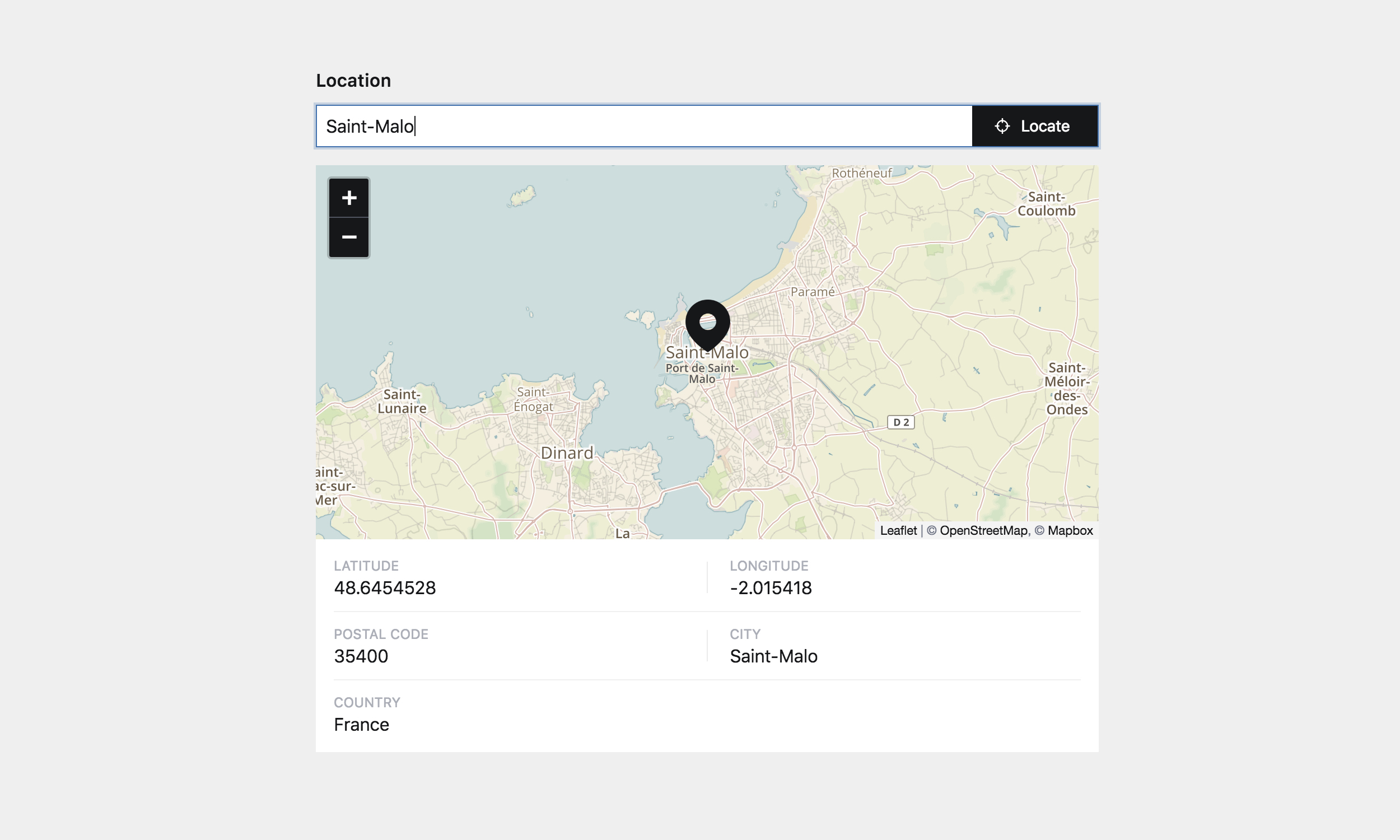
要在面板中显示的信息。请注意,它将仅从面板视图中隐藏它们,但它们仍将存储在.txt文件中(如果可用)。可以从 lat、lon、number、address、postcode、city、region、country 和 countryCode 中选择。默认包括它们所有,但不包括 countryCode。
如果您正在使用Nominatim,字段还将在 osm 键下存储OpenStreetMap ID,您也可以将其添加到列表中显示。
如果您不希望显示任何信息,请将其设置为 false。
mymap:
  type: locator
  display:
    - lat
    - lon
    - number
    - address
    - postcode
    - city
    - region
    - country
    - countryCode
5.6. draggable
如果设置为 true,则在搜索结果不够精确时,标记将可重新定位。移动后,只存储新的 lat 和 lng。默认是 true。
5.7. autocomplete
如果设置为 true,在键入请求时,将显示最多5个建议(当Mapbox用于地理编码时)。默认是 true。
5.8. liststyle
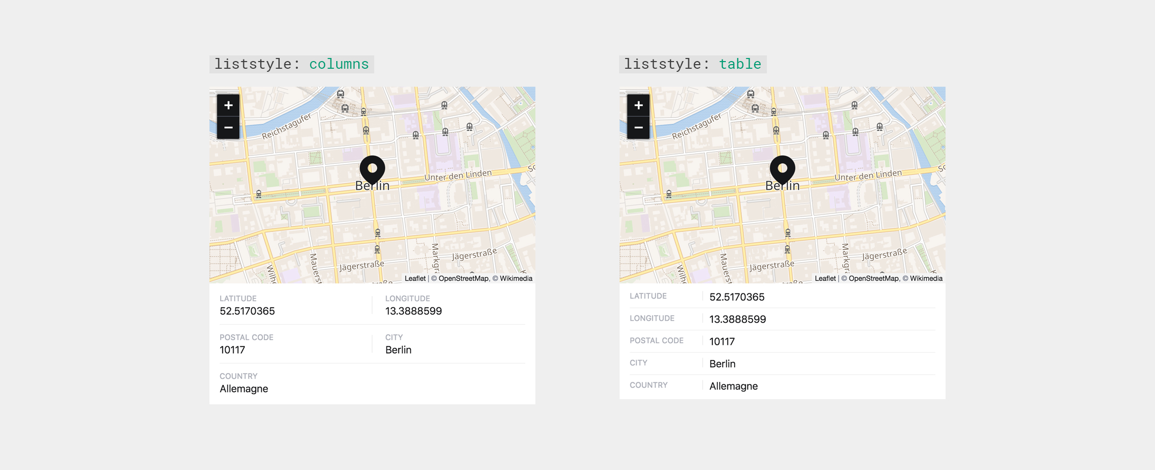
信息块的样式,可以是 columns 或 table。默认是 table。
mymap:
  type: locator
  liststyle: table
5.9. marker
使用的标记颜色,可以是 dark、light 或您的自己的HEX值。默认是 dark。
mymap:
  type: locator
  marker: dark
5.10. language
如果此选项设置为ISO 639-1代码(en、fr、de等),如果可用,地理编码服务将以请求的语言返回结果。默认是 false。
mymap:
  type: locator
  language: false # or 'de' | 'fr' | 'en' | …
5.11. dblclick
地图上的双击是否应触发缩放(zoom)或添加标记/将现有标记移动到单击事件的坐标(marker)。默认是 zoom。
mymap:
  type: locator
  dblclick: zoom # or 'marker'
6. 全局选项
相同的选项在全局范围内可用,这意味着您可以在安装的config.php文件中设置它们所有,而不用担心之后逐个设置。
return array(
    'sylvainjule.locator.center.lat'   => 48.864716,
    'sylvainjule.locator.center.lon'   => 2.349014,
    'sylvainjule.locator.zoom.min'     => 2,
    'sylvainjule.locator.zoom.default' => 12,
    'sylvainjule.locator.zoom.max'     => 18,
    'sylvainjule.locator.saveZoom'     => false,
    'sylvainjule.locator.autoSaveZoom' => false,
    'sylvainjule.locator.display'      => array('lat','lon','number','address','postcode','city','country'),
    'sylvainjule.locator.draggable'    => true,
    'sylvainjule.locator.autocomplete' => true,
    'sylvainjule.locator.liststyle'    => 'columns',
    'sylvainjule.locator.marker'       => 'dark',
    'sylvainjule.locator.language'     => false,
    'sylvainjule.locator.dblclick'     => 'zoom',
);
7. 前端使用
位置数据以YAML格式存储,因此需要使用yaml方法或使用toLocation方法(见下文)进行解码。
$location = $page->mymap()->yaml();
可能的存储键包括
lat(纬度)lon(经度)number(街道号码)address(街道/道路/地点)city(城市/村庄)region(地区/州)country(国家)countryCode(国家代码)osm(OpenStreetMap ID,如果使用Nominatim)
可能找到的位置可能没有这些键之一,因此将不会保存。始终检查键是否存在并且不为空非常重要。以下是一种方法:
$location = $page->mymap()->yaml();

if(!empty($location['postcode'])) {
    // there is a filled 'postcode' key
}
else {
    // there is no / an empty 'postcode' key
}
或者,您可以使用toLocation方法将值转换为新的集合,并使用它以kirby风格。
$location = $page->mymap()->toLocation();

// You now have access to
// $location->lat()
// $location->lon()
// ...

if($location->has('postcode')) {
    if($location->postcode()->isNotEmpty()) {
        // there is a filled 'postcode' key
    }
    else {
        // there is an empty 'postcode' key
    }
}
else {
  // there is no 'postcode' key
}
8. 致谢
服务
- 使用Openstreetmap、Wikimedia、Carto或Mapbox作为瓦片服务器。
- 使用Nominatim或Mapbox Search作为地理编码API。
- 使用Leaflet作为地图库。
K2字段
- Map-field,由@AugustMiller创建。
- 其开源分支kirby-osmap-field,由@fendinger创建。
9. 许可证
MIT